


LAC BOUILLOUSES 1

gallo
User
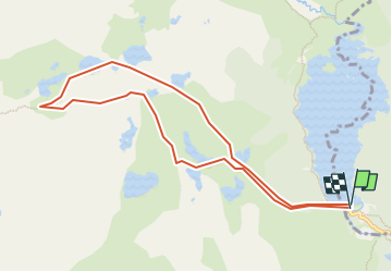

Length
9.9 km

Max alt
2376 m

Uphill gradient
397 m
Km-Effort
15.2 km

Min alt
2003 m

Downhill gradient
396 m
Boucle
Yes
Creation date :
2023-05-07 09:42:17.238
Updated on :
2023-05-07 17:00:22.117
3h27
Difficulty : Difficult

FREE GPS app for hiking
 SityTrail
IGN / Geographical institutes
SityTrail Plus
The world is yours!
About
Trail Walking of 9.9 km to be discovered at Occitania, Pyrénées-Orientales, Les Angles. This trail is proposed by gallo.
Positioning
Country:
France
Region :
Occitania
Department/Province :
Pyrénées-Orientales
Municipality :
Les Angles
Location:
Unknown
Start:(Dec)
Start:(UTM)
418038 ; 4712460 (31T) N.
Comments